Google Flood Hub — Bangladesh Water Development Board's AI-Powered River Flood Alert System
Bangladesh
Since 2020, Google Research's machine-learning flood model — which forecasts river levels even in ungauged basins — has combined with …
Kenya · Kisumu · See the Kenya profile · See the Kisumu profile
Evidence: Observational / pre–post Top 62% 53/100 · Ask Evidence Copilot about this practice
Underwater sensors and AI models built by Kenya's KMFRI and Nairobi's ShoShin Innovation Hub flagged a dissolved-oxygen crash at Dunga Beach, Kisumu in February 2026; over 300 farmers moved 450+ tilapia cages by SMS alert, averting a repeat of $1m in 2024-25 losses.
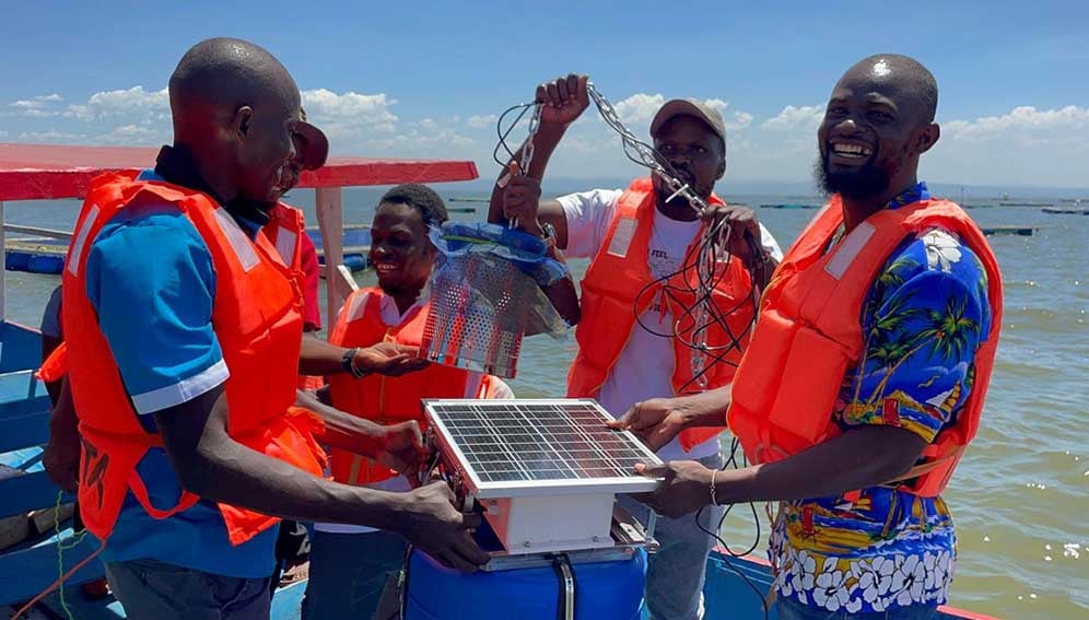
Cage-based tilapia farming on Lake Victoria at Dunga Beach, Kisumu, has suffered episodic mass fish kills from dissolved-oxygen crashes linked to algal blooms fed by untreated urban waste and agricultural runoff. A 2022 KMFRI survey found more than three-quarters of Kenyan fish farmers had experienced mortalities, and 2024-25 oxygen crashes destroyed roughly US$1 million in fish stock at Dunga Beach alone.
Detect dissolved-oxygen crashes early enough to give farmers time to move cages and avert mass fish kills.
Kenya's Marine and Fisheries Research Institute (KMFRI) and the Nairobi-based ShoShin Innovation Hub deployed underwater sensors and cloud-hosted AI models, trained on KMFRI's historical fish-kill research combined with live sensor readings; alerts trigger SMS messages with simple, actionable guidance ('slow feeding', 'move cages') to the feature phones of more than 300 tilapia farmers.
In February 2026 the system flagged a dissolved-oxygen crash below the 2.0 mg/L threshold associated with fish kills; more than 300 farmers relocated more than 450 cages within hours. No further mass fish deaths have been recorded at Dunga Beach since the alert, against a 2024-25 baseline of roughly $1 million in losses at the same site.
Researchers and reporters describe the system as buying farmers the hours between an oxygen crash and a total loss, not as addressing the underlying pollution driving the crashes. Open concerns include rural connectivity gaps, the sustainability of funding once government support tapers off, and unresolved questions about who controls farmers' sensor data over time. KMFRI has identified 15 further high-risk hotspots for possible expansion, with two more sites expected to go live in the second half of 2026, and the NGO WorldFish is adapting a similar approach (E-Samaki) for coastal mariculture sites in Kilifi and Kwale counties.
National / regional programmes
Indicative funding routes for practices of this type — always check each programme's current calls and eligibility rules.
Do you run this practice? Claim it — verified implementers get a public contact pathway and can propose corrections.
Where this practice's information was retrieved from, and when.
Bangladesh
Since 2020, Google Research's machine-learning flood model — which forecasts river levels even in ungauged basins — has combined with …
Fiji
Digital Earth Pacific, run by the Pacific Community (SPC), turns open satellite data into AI-processed disaster-risk, coastline and mangrove products …
Uganda
Uganda launched an AI flash-flood nowcasting system in Kampala (April 2026), blending satellite rainfall, radar and hydrodynamic modelling. It is …
Gabon
Gabon's parks agency ANPN pilots solar-powered, satellite-linked camera traps running on-device AI to detect elephants and alert rangers in real …
Open full copilot Grounded in cited practices — always check the sources.