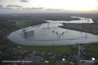
A transboundary depoldered area for flood protection and nature: Hedwige and Prosper Polders
Belgique
None
Belgique · Voir le profil de Belgique
Preuves: Observationnel / avant-après · Demandez à Evidence Copilot à propos de cette pratique
None
The original Sigma Plan conceived in 1977, was designed to protect the coastlines of the Scheldt and its tributaries against storm surge floods. However, as the execution of the plan progressed, new requirements arose including the need for further adaptation to climate change. When the Sigma Plan was updated in 2005, it was understood that the existing plan was insufficient to provide adequate protection both under current conditions as well as for the likely conditions projected by climate change models. The 2005 update referred to a projected range of sea level rise of 9 to 88 cm by 2100, taking into account varying estimates of seawater expansion, melting of the icecaps and glaciers and climate sensitivity; this was based on the IPPC Third Assessment Report, released in 2001. In particular, the Sigma Plan used as a baseline for its protection measures a sea level rise of up to 25 cm by 2050 and 60 cm by 2100. The plan is focused on protection until 2050. Belgium has chosen to apply differentiated flood protection levels along the Scheldt based on the likelihood of deaths and the potential extent of economic damage. The minimum level of protection is a flood event occurring once in 1,000 years (otherwise expressed as the probability of occurrence 0.1% in a year). A number of possible additional measures are prepared for the period after 2050 in case they are needed to address higher sea-level rise. These will be undertaken depending on the advanced projections then available. It should also be noted that the average tidal amplitude of the river has increased significantly during the past century. These changes are largely due to human interventions affecting the flow of water through the Scheldt. Changes include the diverting of water to feed into canals, the removal of river meanders by straightening the river and increasing the depth of shipping channels. These changes exacerbate impacts from climate change.
The main objectives of the Sigma Plan are to protect the land bordering the Scheldt River and its tributaries such as the Rupel, the Nete and the Durme rivers from storm surges and river flooding. Another objective is to restore the Scheldt's ecosystems, helping Belgium meet its EU obligations for nature protection and achieve conservation objectives in the framework of Natura 2000. Moreover, the Sigma Plan aims to make the Scheldt and its tributaries more attractive to cyclists, hikers and other visitors, enhancing different recreational uses of the area.
While the Sigma Plan’s main purpose is flood control, the plan is based on an integrative perspective on river management which acknowledges various river functions and their importance for society. These include: shipping, nature protection, preservation of landscape values, cleansing functions, fish nurseries and more. The Sigma Plan was originally conceived in 1977 with flood control as its main purpose. Since then, perspectives on water management have evolved. An updated Sigma Plan was adopted in 2005. It was based on three main pillars; flood protection, access to Scheldt Ports and a natural functioning of the physical and ecological system. The original Sigma Plan called for dikes stretching a total length of 512 kilometres to be raised and strengthened, the establishment of 13 controlled flood areas covering a total of about 1,100 hectares, as well as the construction of a storm surge barrier. Plans for the storm surge barrier were later suspended after analysis showed that the benefits did not outweigh the costs. The consideration that the storm surge barrier was prohibitively expensive, together with an increased demand for a healthier river ecosystem, led to a greater application of a concept called ‘room for the river’. The 2005 revision also took into account projected climate change impacts. The 2005 plan gives a greater role to controlled flood areas (CFAs) and depoldered areas that counter storm surges by temporarily storing excess water. Controlled flooding areas have low dikes, called overflow dykes, along the river, and higher dykes on the inland side to maintain flood protection. The overflow dykes allow water to flood during storm surges. After high water levels have receded, drainage outlets allow water to exit. The CFAs help attenuate the impacts of flooding events by increasing the river catchment area, thus reducing upstream water levels. The volume of many CFAs is increased as their ground levels are below the average water level due to historic compacting of the soil and loss of natural sedimentation processes. These low ground levels however mean that overflow dikes and artificial water regulation are needed. The predominant use for land within CFAs has been as nature areas that contribute to achieving conservation objectives and improving water quality. Under EU nature legislation – in particular, requirements to compensate for the loss of natural areas taken by the expansion of the Port of Antwerp – the total area set aside as flooding areas was increased for the purpose of nature development: by 2030, a total of about 2,450 hectares are to be created. Another 650 hectares have been indicated as possible future flood zones to be constructed after 2030 if necessary to guarantee flood safety beyond 2050. Some CFAs also include controlled tidal areas, where a regular, reduced tide is produced through an adjustable weir system in the overflow dike. During high tide, water from the Scheldt flows into the area through a weir and during low tide it flows out through a low weir. The controlled tidal areas allow for the creation of tidal habitats while maintaining the CFA’s functions. Depoldering areas are zones where dike protection is moved inland exposing a former polder (land reclaimed from the water) once again to tidal influences. Depoldered areas provide room for river water during high water levels. Thus they, like the CFAs, attenuate storm surge levels. They also provide room for estuarine habitats. The Sigma Plan also includes projects aiming to raise and reinforce river levees for a total length of 645 km. The required thickness and height of the Scheldt river levees have been calculated considering the water pressure on the levees, through simulations of storm tides with computer models. Levees are raised to 8 metres TAW (Tweede Algemene Waterpassing, the reference height for measuring water levels in Belgium) in those areas that are more upstream along the River Scheldt. Levees are raised to 11 metres TAW in the section between Antwerp and the Western Scheldt. The Sigma Plan has already proven its effectiveness in recent years during several storms surges occurred between 2013 and 2018, successfully containing excess water and preventing dangerous flooding. In particular, during the event of the 3 rd January 2018, a strong storm tide caused very high water levels in the Scheldt and its tributaries. Fifteen Flood Control Areas, out of the total sixteen already completed, became operational, buffering the excess water.
In 2005, the total costs for realising the updated Sigma Plan were estimated at 882 million Euros: 830 million for construction works and 52 million Euros for accompanying measures. In 2010, an update of the estimates resulted in a cost estimate of 994 million Euros for the works and 62 million Euros for the accompanying measures, due to mainly to overall price increases. The 2005 Sigma Plan included a detailed cost benefit (CBA) analysis to assist in determining the optimal plan. In total, 180 potential areas were considered for use as controlled flood areas, with a total surface area of 15,000 ha. The CBA took the average annual flood risk during the 100 year project life into account, allowing for a sea level rise of 60 cm and taking into account climate change. The economic risk with only the works of the original (1997) Sigma Plan without the storm surge barrier completed was estimated to be 942 million Euros. From the cost benefit analysis, it was found that the optimal scenario included the raising of dikes and the use of CFAs. The safety benefits of the optimal scenario were estimated to be 736 million Euros. A cost benefit analysis of the ecosystem benefits was also undertaken. This analysis used various available market prices for goods such as for timber production, reed production, carbon dioxide capture, fish production (shrimp), and the prevention of riverbed erosion leading to a reduction in dredging activities. It also used studies to price goods and services with no available market values. Goods and services with no available price information were studied using contingent valuation methods and hedonistic pricing, for example by seeing how housing prices near the project areas could change. The hedonistic price change was estimated using data from other studies while for the contingent valuation study a total of 1,704 questionnaires were collected. The conclusion of the extensive CBA to determine ecosystem benefits found that the benefits range between 143 and 984 million Euros, with the highest level of benefits realised by the maximisation of the use of controlled tidal areas. The non-use value that people attributed by people was the largest benefit measured but also the most contentious. From the cost benefit analysis it was concluded that the benefits outweigh the costs. From an environmental perspective, several benefits and losses can be identified. Benefits include: Restoration of estuarine processes with accompanying water quality gains; Development of more robust nature areas of high quality that are protected at European level; Desirable changes to the sedimentation regime, with increased sedimentation in the inundation zones leading to a lower turbidity in the river; Reduction in tidal energy. Losses include: Loss of former cultural landscapes (mainly agricultural landscapes); Impacts on agriculture and other land use functions in flood zones (monetary compensation and in some cases compensation in the form of alternative agricultural land was provided to farmers) Impacts on valuable groundwater upwelling nature zones and valley ecotypes; Sedimentation impacts on the soil quality in the flood zones. Some benefits of the implementation of the Sigma Plan have been already experienced, with an overall increase of protection of the area during storm surges, as reported in the section about solutions.
Main success factors include: The coordinated identification of suitable areas for the development of controlled flood zones, providing increased safety with limited damage caused to agriculture, land use and economy. The integration of climate change and sea level rise projections. The integration of compensation for areas lost by port expansion and the dredging of the Scheldt in the plan’s overall objectives, strengthening its profile in negotiations with local governments and stakeholders. The availability of areas for the compensation of natural habitats lost due to infrastructure works in the Scheldt Estuary. The ability to expropriate the land necessary for the controlled flood areas. Landholders are compensated for the existing price of the land plus 20%. Where feasible, expropriation can be delayed to the time when a farmer retires or is near to retirement. The ongoing engagement of plan managers with stakeholders during the phases of each project and in the overall decision-making process – this has addressed initial opposition (see limiting factors). Application of cost-benefit analysis (CBA) and environmental impact assessment (EIA) to strengthen plan and project design. Limiting factors include: Stakeholder opposition has been an issue for the construction of the Kruibeke CFA and also in the Netherlands for the Hedwige Polder project. Budget restrictions have slowing the implementation of the plan, which could push its completion beyond the intended date of 2030.
Les détails de mise en œuvre (coût, calendrier, personnel, conditions de réussite) ne sont pas encore disponibles pour cette pratique.
National / regional programmes
Pistes de financement indicatives pour des pratiques de ce type — vérifiez toujours les appels en cours et les règles d'éligibilité de chaque programme.
Vous portez cette pratique ? Revendiquez-la — les porteurs vérifiés obtiennent un contact public sur la page et peuvent proposer des corrections.
D'où proviennent les informations de cette pratique, et quand.
Belgique
None
Belgique
None
Royaume-Uni
Dix ans de recherche de l'Université d'Exeter : débits de pointe ~30 % plus faibles, 6 millions de litres stockés …
Royaume-Uni
Le Fonds de restauration de la nature d'Écosse a investi 65 millions de livres dans près de 800 projets depuis …
Ouvrir le copilote complet Fondé sur des pratiques citées — vérifiez toujours les sources.