Barcelona's Superblocks (Superilles) — From the Poblenou Pilot to a City-Wide Health Model
Spain
Barcelona closed street grids to through-traffic in pilot 'superblocks'; evaluated zones saw NO2 fall 24% and noise fall 5.4%. A …
United States of America · Richmond · See the United States of America profile · See the Richmond profile
Top 4% 91/100 · Ask Evidence Copilot about this practice
In July 2017, 15 volunteer teams in Richmond, Virginia logged 60,000+ car-mounted temperature readings, finding 15–20°F intra-city gaps that helped secure five new parks and ~$1M in tree funding — a protocol NOAA and CAPA Strategies have since run in 120+ communities worldwide.
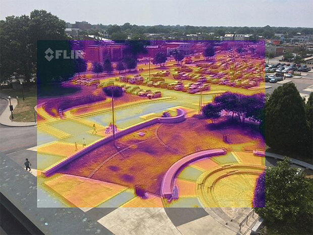
In July 2017, the Science Museum of Virginia, Virginia Commonwealth University, the University of Richmond and Groundwork RVA partnered with Portland State University urban-heat researcher Vivek Shandas to run the first large community heat-mapping campaign in Richmond, Virginia. On one of the summer's hottest days, 15 volunteer teams drove fixed routes at 6am, 3pm and 7pm with car-mounted temperature and humidity sensors, collecting more than 60,000 readings across the city.
The resulting high-resolution map showed that Richmond's most built-up, tree-poor neighbourhoods — disproportionately lower-income and historically redlined areas — ran 15–20°F hotter than leafier parts of the city. City officials cited the data directly in Mayor Levar Stoney's commitment to build five new parks in the city's Southside, and the Chesapeake Bay Foundation used the maps to direct nearly $1 million toward community-driven tree-planting around schools, faith centres and community sites.
NOAA subsequently funded CAPA Strategies, the firm that formalised Richmond's field protocol, to run Heat Watch campaigns nationally; by 2024 the method had been used in over 120 U.S. and international communities. Houston and Harris County's 2024 H3AT campaign — the largest single-day version to date — sent more than 150 volunteers over 3,664 miles of routes, feeding results directly into a tree-equity analysis prioritising planting sites by heat exposure and canopy loss.
Read the full analysis: https://www.climate.gov/news-features/climate-case-studies/where-do-we-need-shade-mapping-urban-heat-islands-richmond
Implementation detail (cost, timeline, staffing, conditions for success) is not yet available for this practice.
Do you run this practice? Claim it — verified implementers get a public contact pathway and can propose corrections.
Where this practice's information was retrieved from, and when.
Spain
Barcelona closed street grids to through-traffic in pilot 'superblocks'; evaluated zones saw NO2 fall 24% and noise fall 5.4%. A …
Serbia
Belgrade's CEUS and city Environmental Protection Secretariat built the Western Balkans' first Urban Living Lab, ratifying a 60-member, 35-institution Partnership …
India
Launched in 1995, Ahmedabad's Parivartan programme used a four-way cost-share between the city, NGOs, private donors and residents to connect …
Peru
Since 2010, Lima Cómo Vamos has surveyed ~2,000 residents of Metropolitan Lima annually on urban quality of life. A 2022 …
Open full copilot Grounded in cited practices — always check the sources.